

From 1880 to today: How Kabul lost control of its water resources
Between 1960 and 1978, urban development plans for Kabul, drawn up with the support of international experts, promoted a technocratic approach to urban modernisation at the expense of traditional water management systems, including engineered streams. Based on archival sources, interviews and secondary data, this article examines how urban planning contributed to weakening the city’s water and territorial resilience. It argues for the reintegration of local knowledge into urban planning policies to restore a sustainable balance between modernisation and water management.
Introduction: Between imposed modernization and the erasure of indigenous practices
Since 1880, Kabul has undergone urban transformation driven by external influences and the gradual marginalization of traditional spatial management practices. By the late 19th century, the capital became a laboratory for modernization projects led by elites, often inspired by foreign models that were poorly compatible with the irrigated meadow systems that had historically structured the valley. This dynamic intensified in the 20th century (Figure 1), particularly during the Cold War.
1 The project was interrupted during the British occupation (1879–1880) and was subsequently abandoned when Emir Abdur-Rahman chose a new royal site southeast of Sherpur, where he built the Arg, the new royal palace. 2 The term Arg is a Dari (modern Persian) word derived from Pahlavi (Middle Persian), meaning “citadel” or “fortress.” In its contemporary usage in Kabul, it refers to the presidential palace and, by extension, the central authority. 3 In the irrigated meadow (awlang) of Chardeh, located near the historic city of Kabul, the area was incorporated in 1924 into the Dar al-Aman project, designed in collaboration with the French architect André Godard under the commission of Emir Amanollah Khan. This project is known as the Dar al-Aman Plan. 4 The “gap” visible in the timeline corresponds to a period of political instability, notably marked by the fall of Amanollah Khan in 1929. This instability interrupted the Dar al-Aman project. Urban development continued neighborhood by neighborhood but without an overarching plan, which explains the absence of a major urban planning framework until the First Master Plan (1960–1964).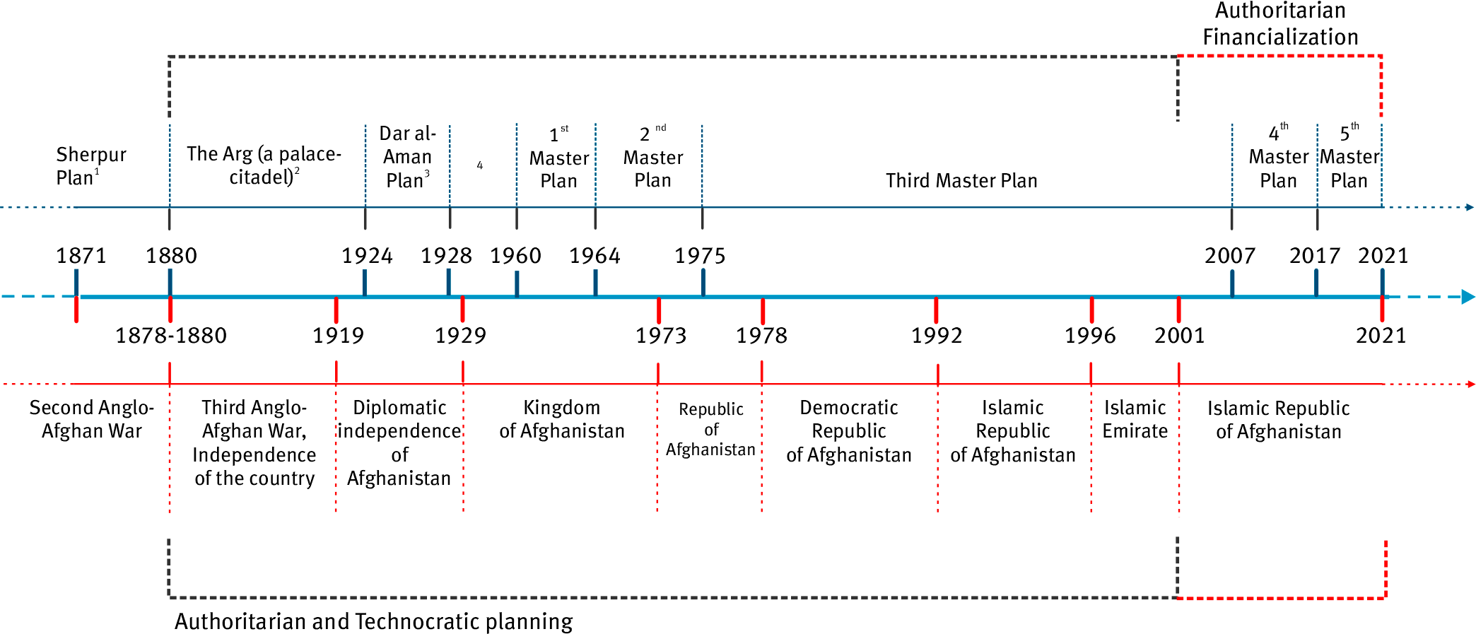
Figure 1. Timeline of Kabul’s Urban Planning (1880–2021).
Between 1960 and 1978, three successive Master Plans were developed with the support of international experts. Based on top-down principles—hygienism, functional zoning, and standardization—these plans overlooked traditional irrigation systems, particularly the engineered streams (juy; see Box 1), which for centuries had structured the territorial and socio-hydraulic organization of the irrigated meadows.
According to Humlum (1959), irrigation refers to techniques used to control soil moisture in order to increase agricultural production; uncontrolled water inputs, such as natural flooding, are not included. In Kabul, this control relied on a structured network of engineered streams (juy), supplemented by a limited number of karez systems in peripheral areas. These infrastructures directed water from local rivers to cultivated lands and urban spaces.
Historically, the city was organized around six irrigated meadows (awlang), each fed by one or more juy. Through infiltration and resurgence, these waterways remained active even during the summer. Their form varied according to the topography: open channels in the plains, small ditches at the base of slopes, and partially buried conduits on the hillsides.
According to Babur, Kabul in the 16th century was distinguished by its social and cultural diversity, supported in part by the relative abundance of water and the collective organization of its meadows. Hydraulic management relied on precise community-based rules, including irrigation rotations, upstream–downstream hierarchies, and shared maintenance. Some rules were inspired by religious principles, while others originated from oral traditions. The gradual disappearance of these systems in the 20th century led to the loss of a hydraulic governance model based on local autonomy and social cohesion.
This article offers a critical analysis of these three plans based on archival sources, interviews, and secondary data. It highlights the role of urban planning as a tool of power and emphasizes the need to reintegrate local water management practices into Kabul’s development frameworks to strengthen the city’s hydrological and territorial resilience.
Master plans on unstable ground: logic of assistance and overlooking local context
The three successive Master Plans (1964, 1975, and 1978) were designed to manage Kabul’s rapid expansion. Their development took place in a context of political instability marked by coups, regime changes, and growing dependence on international aid. This instability limited institutional continuity and hindered the creation of a genuine local urban planning memory.
These plans relied heavily on a logic of technical assistance.
- The first Master Plan, led by Roger Aujame under the auspices of the United Nations (1960–1964), adopted principles derived from European functionalism.
- The second, developed within the framework of the United Nations Development Programme (UNDP), focused on housing and building regulation.
- The third, financed by the Soviet Union and the Afghan government (1976–1978), aimed at rapid industrialization.
In all three cases, the methodology relied on macroeconomic data, demographic projections, and standardized zoning models, with limited grounding in local social, hydraulic, and territorial practices.
However, Kabul possesses a long-standing urban tradition, including autonomous neighborhoods (gozar), community-based irrigation systems, gravity-fed water distribution through juy (streams), and earthen brick architecture adapted to the climate. These local forms of knowledge, which are essential to the city’s hydrological and agricultural functioning, are absent from the Master Plans, where they are often regarded as archaic or informal.
Hydraulic Legacies of Kabul: From Timurid Systems to Irrigated Meadows
From the 15th and 16th centuries onward, Kabul’s hydraulic infrastructure underwent significant development. Ulugh Beg II, a Timurid ruler and paternal uncle of Babur—the future founder of the Mughal Empire—played a decisive role in improving these systems. His reign was marked by substantial investment in irrigation infrastructure and the creation of gardens, building upon pre-existing works.
In his memoirs, Babur describes the intensive use of Kabul’s streams, particularly the Bala Juy (“upper stream”), which supplied the Bala-Hesar palace and the gardens located at the foot of Sher Darwaza (see Figures 2 and 3). This canal constituted a key element of the historic urban landscape and supported agricultural and residential areas around the Char Chatta bazaar (“Four Arches”), built during the reign of Shah Jahan using hydraulic techniques comparable to those employed in the Shalimar Gardens in Lahore and the Taj Mahal in Agra (see Figure 4).
Babur also notes that Kabul was structured around six major irrigated meadows (awlang), including that of Chardeh (see Figure 5), located near the historic city and traversed by the Bala Juy. In 1924, this area was incorporated into the Dar al-Aman project, developed in collaboration with the French architect André Godard. The irrigation system of these meadows relied on a network of dams, secondary canals, and diversion structures, constructed using stone, earth, or branches. These infrastructures played a central role in agriculture, domestic water supply, and social organization.
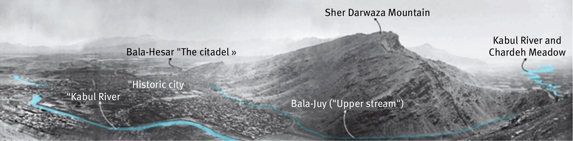
Figure 2. A panorama of Kabul, dated 1879–1880, shows that the source of the Bala Juy originates more than six kilometers upstream from the city (Schinasi, 2008, pl. 2a–b).
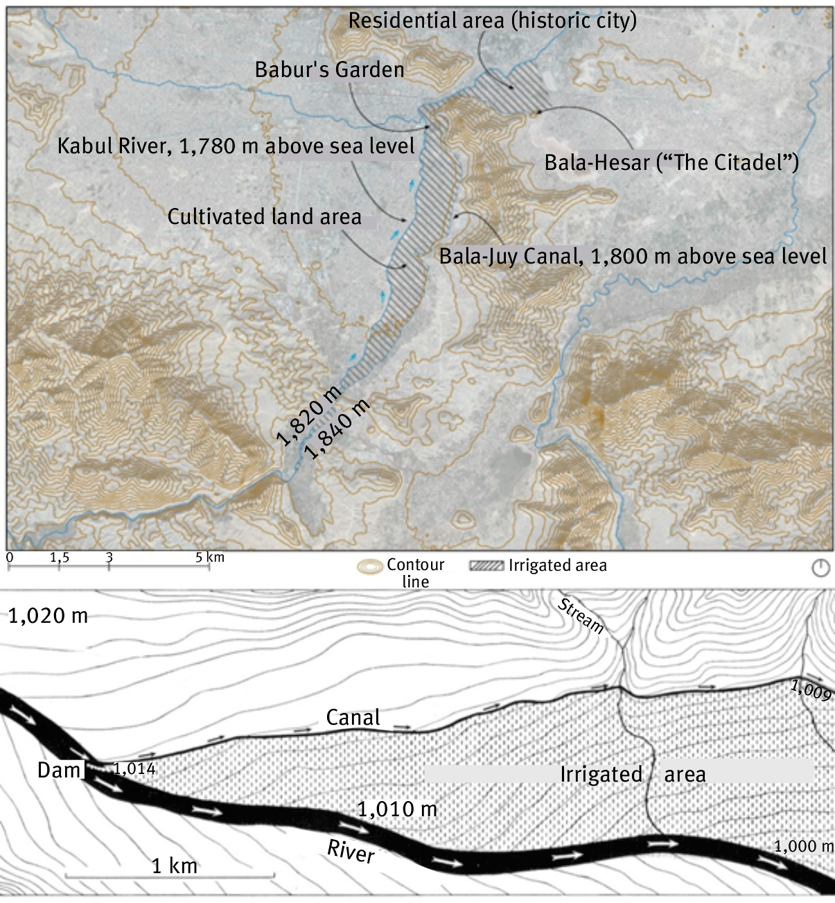
Figure 3. The first image illustrates the irrigation scheme of the Bala Juy in Kabul (Rahimi). The second image presents a representation of a Bala Juy–type irrigation system using river water (Humlum, 1959, Figure 206, p. 206).
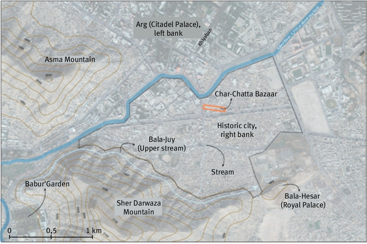
Figure 4. According to various accounts, the Char Chatta bazaar and the Bala-Hesar of Kabul were supplied by the Bala Juy canal, while the bazaar’s fountains in the 17th century flowed due to a favorable topographical configuration.
Babur mentionne également que Kaboul est structurée en six grandes prairies irriguées (awlang), dont celle de Chârdeh (figure 5), proche de la ville historique et traversée par le Bâlâ Juy. En 1924, cette zone est intégrée dans le projet de Dâr ol-Amân, conçu en collaboration avec l’architecte français André Godard. Le système d’irrigation de ces prairies repose sur un ensemble de barrages, de canaux secondaires et de dérivations, construits avec des pierres, de la terre ou des branches. Ces infrastructures jouent un rôle central dans l’agriculture, l’approvisionnement domestique et l’organisation sociale.
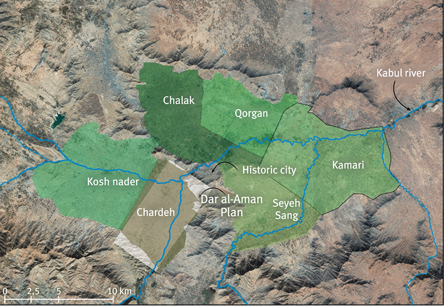
Figure 5. nitial Plan of Dar al-Aman, located in the Chardeh Meadows, Kabul.
Trois Master Plans, un même aveuglement : analyse comparative (1960-1978 Three Master Plans, one shared blindness: a comparative analysis (1960–1978)
This long-standing tradition of hydraulic urbanism provides an essential framework for understanding the shortcomings of the 20th-century Master Plans. The analysis is structured around three main axes:
1. The technical content of the plans (objectives, assumptions, and spatial representations);
2. The modes of development (actors involved, decision-making processes, and circulation of knowledge);
3. The territorial impacts on access to water, urban fragmentation, and forms of housing.
The first Master Plan (1960–1964): Functional grid and authoritarian modernization
Commissioned to Roger Aujame as part of a United Nations mission, the first plan was based on a functionalist vision inspired by European modernism. It proposed an urban organization structured around zoning (residential, administrative, commercial, and recreational), the geometrization of space, and the creation of perpendicular circulation axes.
However, this framework overlooked Kabul’s historical morphology, characterized by compact settlement patterns, strong functional diversity, neighborhood organization into gozar, and, above all, a gravity-fed irrigation system based on juy. Essential elements such as the Bala Juy and the hydraulic logic of the irrigated meadows were neither adequately understood nor integrated into the plan. Aujame himself acknowledged the lack of reliable hydrological data, yet his assessment failed to account for the complexity of vernacular systems.
On the ground, the outcomes were limited: the proposed layouts did not correspond to existing urban forms or local practices. The plan focused on road infrastructure and the relocation of administrative institutions, while informal housing expanded freely, particularly on mountainous slopes. The lack of adequate hydraulic infrastructure and sanitation systems exacerbated inequalities in access to water in these areas.
The second Master Plan (1970–1975): Demographic growth and the invisibilization of water
The second Master Plan, supported by the United Nations Development Programme (UNDP), built upon the orientations of the previous plan while expressing more explicit operational ambitions. It projected a population of 1.2 million inhabitants, with provisions for revision every five years. Its approach prioritized the development of residential neighborhoods and industrial zones but continued to overlook the hydrological dimension.
Several key spaces, particularly wetlands, were urbanized: marshes initially designated as public parks were subdivided, irrigated meadows were converted into residential areas, and streams were channeled, obstructed, or removed from maps. The green spaces proposed in planning documents remained largely theoretical and were quickly reassigned under land pressure.
Actual urban dynamics escaped institutional control: informal settlements expanded beyond the planned perimeter, relying on autonomous water extraction systems, improvised septic tanks, and illegal connections. Due to limited resources, authorities tolerated these practices, rendering the plan ineffective.
The third Master Plan (1976–1978): Planned industrialization and the erasure of the hydraulic landscape
Developed in cooperation with the Soviet Union, the third Master Plan marked a turning point through its industrial ambition. It set a target population of 2 million inhabitants, planned the construction of high-rise buildings (up to 16 stories), and proposed a peripheral ring road (KCORR) intended to structure urban expansion.
The standardized Soviet model was based on the control of nature and the artificialization of hydraulic systems. Traditional irrigation was no longer integrated into the urban structure and was instead confined to a few peripheral agricultural zones. Water supply relied almost entirely on pumping stations, with little consideration for groundwater recharge. The juy, including the Bala Juy, were removed, buried, or rendered invisible, erasing a centuries-old network that had structured social and agricultural practices.
Rural exodus further intensified these imbalances: informal settlements expanded rapidly, relying on autonomous water extraction systems without sanitary regulation. This increased pressure on groundwater resources foreshadowed significant risks of contamination in the following decades.
A problematic continuity: The shared blind spots of the three plans
Despite differing contexts, funding sources, and priorities, the three Master Plans exhibit significant convergences:
- Ignorance of social and territorial dynamics, particularly the irrigated meadows and juy networks that historically structured the city.
- Primacy given to imported, standardized models that were poorly adapted to local conditions.
- Misunderstanding or active suppression of local practices, often regarded as archaic or informal.
This centralized approach, intended to modernize Kabul, resulted in a fragmented city:
- Planned neighborhoods that remained underutilized;
- Dynamic informal urbanization, organized on the margins of official norms.
Water management is the area in which this duality is most visible: fragmented networks, overextraction of groundwater, destruction of irrigation streams, and weakening of local solidarities. These blind spots have fostered a lasting water vulnerability that remains perceptible today.
The table 1 below summarizes these continuities and highlights the recurring blind spots of the three Master Plans, showing how theoretically different approaches ultimately produced similar effects on water management and urban structuring.
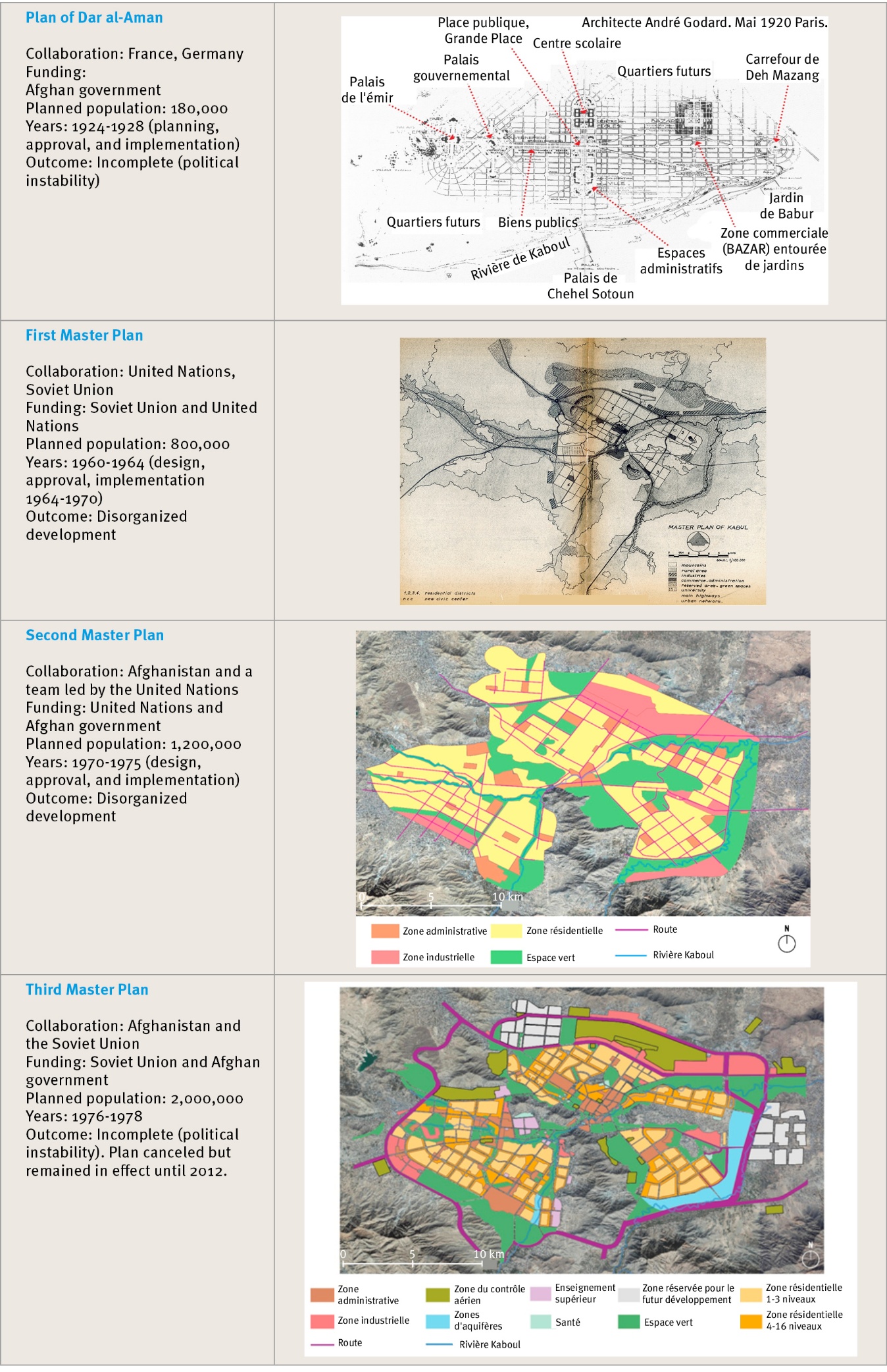
Table 1. Continuities in Urban planning in Kabul.
Conclusion: Between structural ignorance and silent resilience—rethinking urban planning in Kabul
Between 1960 and 1978, Kabul’s three Master Plans reflect a consistent dynamic of erasing vernacular practices in favor of authoritarian, externally and ideologically driven planning. The marginalization of irrigated meadows and juy—central elements in an arid and hydrologically fragile territory—illustrates the limits of this approach. Across all three plans, the same blind spot persists: the absence of dialogue with the population, which was treated not as an active participant in urban development but merely as a recipient of decisions. No participatory process was implemented, and interviews conducted as part of this research confirm that residents were never informed or consulted regarding the chosen orientations (Rahimi, 2023).
Beyond technical aspects or uncontrolled urban growth, Kabul’s recent history highlights the weakening of community-based mechanisms for territorial management. By disregarding collective knowledge, authorities undermined self-regulatory structures that had previously ensured coherence between housing, agriculture, and water management. The gradual disappearance of streams and irrigated meadows disrupted these socio-hydraulic balances.
Rethinking urban planning in Kabul requires rehabilitating these territorial logics without idealizing the past. This approach does not entail simply reinstating traditional forms as they were, nor rejecting modern planning, but rather constructing a renewed articulation between institutional expertise and local knowledge. Even a partial restoration of hydraulic continuities, particularly through the still-existing juy, could strengthen urban resilience while reconnecting the city to its socio-environmental foundations.
However, the authoritarian and technocratic planning inherited from the twentieth century is now giving way to an equally centralized financialized approach in the twenty-first century, which once again tends to neglect the integration of juy within the city (Figure 1). This shift reveals the persistence of urbanism disconnected from Kabul’s socio-hydraulic realities. Although this article cannot explore the issue in detail, it opens a necessary field of research on contemporary forms of governance, the financialization of urban projects—in both formal and informal areas—and the evolution of the fourth and fifth Master Plans.
________________________
References
- Aujame, R. (1965). Fonds Aujame. SIAF (Service interministériel d’archives en France)/Cité de l’architecture et du patrimoine/Archives d’architecture contemporaine.
- Babur, Z. M. (2017). Baburnama (A. S. Beveridge, Trad.). Rupa Publications India.
- Bacharyar, W. (1974a). Étude d’aménagement et de développement de la région de Kaboul (Vol. II). Université de Paris VIII.
- Bacharyar, W. (1974b). Les possibilités d’aménagement du territoire et de régionalisation en Afghanistan (Vol. I). Université de Paris VIII.
- Barry, M. (2021). Le cri afghan. L’Asiathèque.
- Beyer, E. (2012). Competitive coexistence: Soviet planning and housing projects in Kabul in the 1960s. The Journal of Architecture, 17(3), 309-332. http://dx.doi.org/10.1080/13602365.2012.692598
- Bourg, D., & Fragnière, A. (Eds.). (2014). La pensée écologique : Une anthologie. Universités de France.
- Boyer, B. (2010). Villes afghanes, défis urbains. KARTHALA.
- Breshna, Z. (2004). Das historische Zentrum von Kabul, Afghanistan. Grundlagenermittlung für eine Strategie der Wiederbelebung [Le centre historique de Kaboul, Afghanistan : Identification des bases d’une stratégie de régénération]. Allemagne, s.l.
- Callon, M., Lascoumes, P., & Barthe, Y. (2001). Agir dans un monde incertain : Essai sur la démocratie technique. Seuil.
- Calogero, P. A. (2011). Planning Kabul: The politics of urbanization in Afghanistan [Thèse non publiée]. University of California, Berkeley.
- Cosnard, D. (2021, 22 janvier). Et au milieu de Paris recoulera peut-être la Bièvre. Le Monde.fr.
- Elphinstone, M. (1814). An account of the kingdom of Caubul and its dependencies in Persia, Tartary, and India. Comprising a view of the Afghaun Nation and a history of the Dooraunee monarchy. London.
- Ghulami, M. (2017). Assessment of climate change impacts on water resources and agriculture in data-scarce Kabul basin, Afghanistan [Mémoire de Master]. University Côte d’Azur & Asian Institute of Technology.
- Habib, H. (2014a). Water related problems in Afghanistan. International Journal of Educational Studies, 1(3), 137-144.
- Hopkins, B. D. (2022, janvier 18). Afghanistan’s present failure lies in its past design. Middle East Research and Information Project. https://www.merip.org/2022/01/afghanistans-present-failure-lies-in-its-past-design/
- Houben, G., & Tunnermeier, T. (2005). Hydrogeology of the Kabul Basin (Parts I–III, Vol. III). BGR, Hanover.
- Humlum, J. (1959). La géographie de l’Afghanistan : Étude d’un pays aride (avec des chapitres de M. KØIE & K. FERDINAND). Gyldendal.
- Issa, C. (2009). Construire la culture comme symbole de l’identité nationale : L’exemple de Kaboul, en Afghanistan [Baukultur als Symbol nationaler Identität]. Université Justus-von-Liebig de Giessen.
- Javid, A. A. (1999). Avesta: A glance on the historical geography of Ariyana, Kurasan and Afghanistan. R.R.M All Tryck.
- Jowandoon. (1972). Le plan de 25 ans de la ville de Kaboul serait mis en œuvre. Jowandoon.
- Jowandoon. (n.d.). Une brève histoire de Jowandoon : Le magazine perdu d’Afghanistan. BBC News. https://www.bbc.com/
- Kazimee, B. A. (Ed.). (2016). Sustainable urban forms: Theory, design and application. Cognella.
- Kohzad, A. A. (2015). Bala-Hissâr de Kaboul et ses événements historiques (Vol. 2). Maiwand.
- Kollar, J., Nideroest, T., & Rahimi, M. (2022). A reflexive approach to uncertainty: Situating planning practice in the landscape of Afghanistan’s city regions. AR&D Publishing. (Collection « Landscape approach, from local communities to territorial systems »).
- Lefebvre, H. (2009). Le droit à la ville (3e éd.). Economica.
- Magnaghi, A. (2003). Le projet local. Mardaga.
- Oeppen, C. (2009). A stranger at home: Integration, transnationalism and the Afghan elite [Thèse non publiée]. University of Sussex.
- PARGAR. (2011, 11 juin). PARGAR, 2011, London [Vidéo]. YouTube. https://www.youtube.com/watch?v=p3xbEVDI8Dw
- Rahimi, M. (2023). La planification de Kaboul : la connaissance locale comme projet pour « sauver » l’eau [Thèse]. Université Bordeaux Montaigne. Thèses.fr. https://theses.fr/2023BOR30045
- Sahab, S. (2017). A study on neighborhood unit model for inner city Kabul, Afghanistan [Mémoire non publié]. Nagoya, Japan.
- Schinasi, M. (1979). Afghanistan at the beginning of the twentieth century: Nationalism and journalism in Afghanistan. A study of Serâj ul-akhbâr (1911–1918). Naples.
- Schinasi, M. (2008). Kaboul 1773-1948: Naissance et croissance d’une capitale royale. Naples: Università degli Studi di Napoli L’Orientale.
- Tadjik, S. (2017). L’enracinement des traditions ethniques pachtounes, tadjikes et hazaras : Vers une coexistence harmonieuse et la construction d’une identité singulière dans l’architecture résidentielle contemporaine de Kaboul. Téhéran, Iran.
Abstract
Between 1960 and 1978, Kabul was the scene of centralized urban planning marked by the development of three Master Plans, designed with the support of Soviet and UN experts. These plans, based on a technocratic approach, aimed to modernize the city, but proved unsuited to local social and territorial contexts. The analysis, based on the work of Roger Aujame, Pietro Calogero, and Elke Beyer, reveals a marginalization of vernacular knowledge, particularly in the area of water management. The removal of traditional irrigation systems, urban streams, and meadows contributed to the worsening of territorial imbalances and water vulnerability. This study highlights the negative effects of top-down urban planning that is disconnected from socio-environmental realities, promoting informal urbanization and loss of control over water resources. It calls for more inclusive planning that integrates local knowledge as an essential lever for sustainable water management in Kabul.